
Make a donation
Gear up for your next adventure:
As an Amazon Associate, this site earns from qualifying purchases at no extra cost to you.
Yuanlin City topographic map
Click on the map to display elevation.
Make a donation
Gear up for your next adventure:
As an Amazon Associate, this site earns from qualifying purchases at no extra cost to you.
Yuanlin City
Yuanlin has a station on the Taiwan Railways Administration's Western Line. A project is underway to redevelop the station in combination with converting the current at-grade line to an elevated line through the city, a plan designed to improve road traffic flow and promote investment. The elevation of the track will eliminate three level crossings and five underpasses, and the area currently comprising the station will be converted into a mixed-use development with commercial space, parking and green space. This redevelopment was scheduled to be completed in 2013 and has a budget of NT$4 billion.
Make a donation
Gear up for your next adventure:
As an Amazon Associate, this site earns from qualifying purchases at no extra cost to you.
About this map
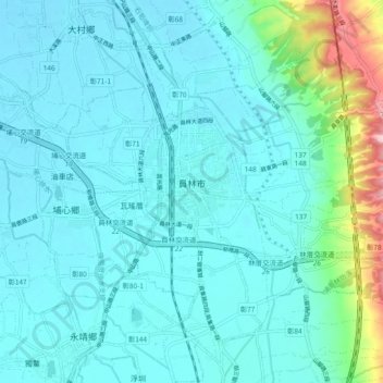
Name: Yuanlin City topographic map, elevation, terrain.
Location: Yuanlin City, Changhua County, Taiwan Province, Taiwan (23.92324 120.54403 23.99036 120.63765)
Average elevation: 52 m
Minimum elevation: 16 m
Maximum elevation: 274 m
Make a donation
Gear up for your next adventure:
As an Amazon Associate, this site earns from qualifying purchases at no extra cost to you.