
Make a donation
Gear up for your next adventure:
As an Amazon Associate, this site earns from qualifying purchases at no extra cost to you.
Tshuapa topographic map
Click on the map to display elevation.
Make a donation
Gear up for your next adventure:
As an Amazon Associate, this site earns from qualifying purchases at no extra cost to you.
About this map
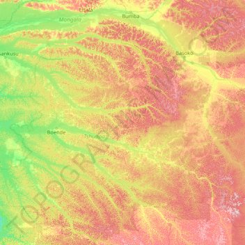
Name: Tshuapa topographic map, elevation, terrain.
Location: Tshuapa, Democratic Republic of the Congo (-2.76947 19.69450 2.43053 24.89450)
Average elevation: 412 m
Minimum elevation: 308 m
Maximum elevation: 691 m
Make a donation
Gear up for your next adventure:
As an Amazon Associate, this site earns from qualifying purchases at no extra cost to you.
Other topographic maps
Click on a map to view its topography, its elevation and its terrain.
North Kivu
Democratic Republic of the Congo
Situated along the equator, North Kivu spans latitudes from 0° 58' north to 2° 03' south and longitudes from 27° 14' west to 29° 58' east. Its topography ranges from less than 800 meters to peaks exceeding 5,000 meters in altitude, comprising diverse formations including plains, plateaus, and mountainous…
Average elevation: 1,189 m
Make a donation
Gear up for your next adventure:
As an Amazon Associate, this site earns from qualifying purchases at no extra cost to you.
Makutano
Democratic Republic of the Congo > Haut-Katanga > Ville de Lubumbashi > Lualaba
Average elevation: 1,210 m
Murung
Democratic Republic of the Congo > Haut-Katanga > Ville de Lubumbashi > Kaponda Sud
Average elevation: 1,212 m
Make a donation
Gear up for your next adventure:
As an Amazon Associate, this site earns from qualifying purchases at no extra cost to you.
Kasungami
Democratic Republic of the Congo > Haut-Katanga > Ville de Lubumbashi
Average elevation: 1,238 m
Makutano
Democratic Republic of the Congo > Haut-Katanga > Ville de Lubumbashi > Lubumbashi
Average elevation: 1,243 m
Make a donation
Gear up for your next adventure:
As an Amazon Associate, this site earns from qualifying purchases at no extra cost to you.
Luano
Democratic Republic of the Congo > Haut-Katanga > Ville de Lubumbashi
Average elevation: 1,295 m
Make a donation
Gear up for your next adventure:
As an Amazon Associate, this site earns from qualifying purchases at no extra cost to you.
Munua
Democratic Republic of the Congo > Haut-Katanga > Ville de Lubumbashi
Average elevation: 1,271 m
Make a donation
Gear up for your next adventure:
As an Amazon Associate, this site earns from qualifying purchases at no extra cost to you.
Masamba
Democratic Republic of the Congo > Haut-Katanga > Ville de Lubumbashi > Lubumbashi
Average elevation: 1,250 m
Make a donation
Gear up for your next adventure:
As an Amazon Associate, this site earns from qualifying purchases at no extra cost to you.
Make a donation
Gear up for your next adventure:
As an Amazon Associate, this site earns from qualifying purchases at no extra cost to you.
Solola
Democratic Republic of the Congo > Haut-Katanga > Ville de Lubumbashi > Kampemba
Average elevation: 1,228 m
Make a donation
Gear up for your next adventure:
As an Amazon Associate, this site earns from qualifying purchases at no extra cost to you.
Make a donation
Gear up for your next adventure:
As an Amazon Associate, this site earns from qualifying purchases at no extra cost to you.
Lake Tanganyika
Democratic Republic of the Congo
The lake has a complex history of changing flow patterns, due to its high altitude, great depth, slow rate of refill, and mountainous location in a turbulently volcanic area that has undergone climate changes. Apparently, it has rarely in the past had an outflow to the sea. It has been described as…
Average elevation: 1,064 m
Make a donation
Gear up for your next adventure:
As an Amazon Associate, this site earns from qualifying purchases at no extra cost to you.
Make a donation
Gear up for your next adventure:
As an Amazon Associate, this site earns from qualifying purchases at no extra cost to you.
Kundelungu
Democratic Republic of the Congo > Haut-Katanga > Ville de Lubumbashi > Lubumbashi
Average elevation: 1,243 m
Make a donation
Gear up for your next adventure:
As an Amazon Associate, this site earns from qualifying purchases at no extra cost to you.
Bana Katanga
Democratic Republic of the Congo > Haut-Katanga > Ville de Lubumbashi > Bana Katanga
Average elevation: 1,201 m
Lava Lake of Mount Nyiragongo
Democratic Republic of the Congo > North Kivu > Nyiragongo
Average elevation: 3,084 m
Bunia
Democratic Republic of the Congo > Ituri
It lies at an elevation of 1,275 metres or 4,180 feet on a plateau about 30 kilometres or 19 miles west of Lake Albert in the Albertine Rift, and about 25 kilometres or 16 miles east of the Ituri Rainforest.
Average elevation: 1,273 m
Make a donation
Gear up for your next adventure:
As an Amazon Associate, this site earns from qualifying purchases at no extra cost to you.
Météo
Democratic Republic of the Congo > Haut-Katanga > Ville de Lubumbashi > Lubumbashi
Average elevation: 1,251 m
Make a donation
Gear up for your next adventure:
As an Amazon Associate, this site earns from qualifying purchases at no extra cost to you.
Make a donation
Gear up for your next adventure:
As an Amazon Associate, this site earns from qualifying purchases at no extra cost to you.
Kasanda
Democratic Republic of the Congo > Haut-Katanga > Ville de Lubumbashi > Matoleo
Average elevation: 1,303 m