
Old Man of Coniston topographic map
Interactive map
Click on the map to display elevation.
About this map
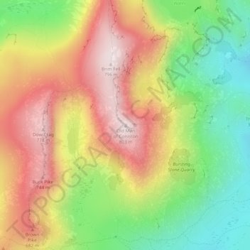
Name: Old Man of Coniston topographic map, elevation, terrain.
Average elevation: 500 m
Minimum elevation: 208 m
Maximum elevation: 796 m
Other topographic maps
Click on a map to view its topography, its elevation and its terrain.
Skelwith Bridge
Royaume-Uni > Angleterre > Cumbria > South Lakeland > Skelwith Bridge
Skelwith Bridge, South Lakeland, Cumbria, Angleterre du Nord-Ouest, Angleterre, LA22 9NW, Royaume-Uni
Average elevation: 133 m
Coniston
Royaume-Uni > Angleterre > Cumbria > South Lakeland > Coniston
Coniston, South Lakeland, Cumbria, Angleterre du Nord-Ouest, Angleterre, Royaume-Uni
Average elevation: 282 m
River Leven
Royaume-Uni > Angleterre > Cumbria > South Lakeland > Backbarrow
River Leven, Backbarrow, South Lakeland, Cumbria, Angleterre du Nord-Ouest, Angleterre, LA12 8NB, Royaume-Uni
Average elevation: 68 m