
Make a donation
Gear up for your next adventure:
As an Amazon Associate, this site earns from qualifying purchases at no extra cost to you.
Reno No. 51 topographic map
Click on the map to display elevation.
Make a donation
Gear up for your next adventure:
As an Amazon Associate, this site earns from qualifying purchases at no extra cost to you.
Reno No. 51
Govenlock-Nashlyn-Battle Creek Grasslands (SK 039) is an Important Bird Area (IBA) of Canada located at the south-western corner of the RM of Reno. It is a rectangular-shaped IBA site with the southern boundary running along the border with Montana. The western boundary runs up for 35 kilometres (22 mi) along the border with Alberta and the northern boundary extends towards the communities of Govenlock and Nashlyn and Battle Creek. From Nashlyn, it heads straight south back to the U.S. border. The site totals 840.03 km2 (324.34 sq mi) and has an elevation range of 903 to 1,001 metres. Access is from Highway 21.
Make a donation
Gear up for your next adventure:
As an Amazon Associate, this site earns from qualifying purchases at no extra cost to you.
About this map
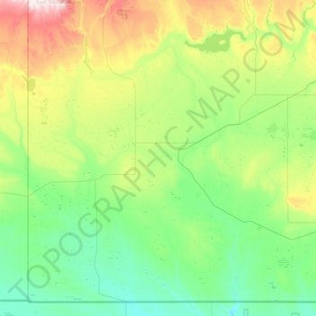
Name: Reno No. 51 topographic map, elevation, terrain.
Location: Reno No. 51, Division No. 4, Saskatchewan, Canada (48.99961 -110.00509 49.52464 -109.12257)
Average elevation: 966 m
Minimum elevation: 825 m
Maximum elevation: 1,391 m
Make a donation
Gear up for your next adventure:
As an Amazon Associate, this site earns from qualifying purchases at no extra cost to you.
Other topographic maps
Click on a map to view its topography, its elevation and its terrain.
Make a donation
Gear up for your next adventure:
As an Amazon Associate, this site earns from qualifying purchases at no extra cost to you.
Make a donation
Gear up for your next adventure:
As an Amazon Associate, this site earns from qualifying purchases at no extra cost to you.
Whitecap Dakota First Nation
Canada > Saskatchewan > Whitecap Dakota First Nation
Average elevation: 495 m
Morin Lake
Canada > Saskatchewan > Northern Saskatchewan Administration District > Morin Lake
Average elevation: 385 m
Make a donation
Gear up for your next adventure:
As an Amazon Associate, this site earns from qualifying purchases at no extra cost to you.
Black Lake
Canada > Saskatchewan > Northern Saskatchewan Administration District > Black Lake
Average elevation: 293 m
Make a donation
Gear up for your next adventure:
As an Amazon Associate, this site earns from qualifying purchases at no extra cost to you.
Make a donation
Gear up for your next adventure:
As an Amazon Associate, this site earns from qualifying purchases at no extra cost to you.
La Loche
Canada > Saskatchewan > Northern Saskatchewan Administration District > La Loche
Average elevation: 447 m
Waterloo Lake
Canada > Saskatchewan > Northern Saskatchewan Administration District
Average elevation: 286 m
Make a donation
Gear up for your next adventure:
As an Amazon Associate, this site earns from qualifying purchases at no extra cost to you.
Air Ronge
Canada > Saskatchewan > Northern Saskatchewan Administration District > Air Ronge
Average elevation: 369 m
Garson Lake
Canada > Saskatchewan > Northern Saskatchewan Administration District > Garson Lake
Average elevation: 470 m
Stony Rapids
Canada > Saskatchewan > Northern Saskatchewan Administration District
Average elevation: 227 m
Make a donation
Gear up for your next adventure:
As an Amazon Associate, this site earns from qualifying purchases at no extra cost to you.
Hall Lake
Canada > Saskatchewan > Northern Saskatchewan Administration District > Hall Lake
Average elevation: 391 m
Zeden Lake
Canada > Saskatchewan > Northern Saskatchewan Administration District
Average elevation: 526 m
Make a donation
Gear up for your next adventure:
As an Amazon Associate, this site earns from qualifying purchases at no extra cost to you.