
Barcelonnette topographic map
Click on the map to display elevation.
Barcelonnette
Barcelonnette is situated in the wide and fertile Ubaye Valley, of which it is the largest town. It lies at an elevation of 1132 m (3717 ft) on the right bank of the Ubaye River, and is surrounded by mountains which reach peaks of over 3000 m; the tallest of these is the Needle of Chambeyron at 3412 m. Barcelonnette is situated 210 km from Turin, 91 km from Nice and 68 km from Gap.
About this map
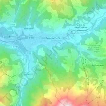
Name: Barcelonnette topographic map, elevation, terrain.
Average elevation: 1,478 m
Minimum elevation: 1,105 m
Maximum elevation: 2,650 m
Other topographic maps
Click on a map to view its topography, its elevation and its terrain.
Saint-Michel
France > Provence-Alpes-Côte d'Azur > Alpes-de-Haute-Provence > Moustiers-Sainte-Marie
Average elevation: 731 m
Chavailles
France > Provence-Alpes-Côte d'Azur > Alpes-de-Haute-Provence > Prads-Haute-Bléone
Average elevation: 1,491 m
Revest
France > Provence-Alpes-Côte d'Azur > Alpes-de-Haute-Provence > Malijai
Average elevation: 524 m
Mont d'Or
France > Provence-Alpes-Côte d'Azur > Alpes-de-Haute-Provence > Manosque
Average elevation: 394 m
La Croix
France > Provence-Alpes-Côte d'Azur > Alpes-de-Haute-Provence > Jausiers
Average elevation: 2,128 m
Le Caravon
France > Provence-Alpes-Côte d'Azur > Alpes-de-Haute-Provence > Oppedette
Average elevation: 553 m
Molanès
France > Provence-Alpes-Côte d'Azur > Alpes-de-Haute-Provence > Uvernet-Fours
Average elevation: 1,566 m
Saint-Michel
France > Provence-Alpes-Côte d'Azur > Alpes-de-Haute-Provence > Moustiers-Sainte-Marie
Average elevation: 731 m
Barcelonnette
France > Provence-Alpes-Côte d'Azur > Alpes-de-Haute-Provence > Barcelonnette > Barcelonnette
Barcelonnette is situated in the wide and fertile Ubaye Valley, of which it is the largest town. It lies at an elevation of 1132 m (3717 ft) on the right bank of the Ubaye River, and is surrounded by mountains which reach peaks of over 3000 m; the tallest of these is the Needle of Chambeyron at 3412 m.…
Average elevation: 1,494 m
La Foux d'Allos
France > Provence-Alpes-Côte d'Azur > Alpes-de-Haute-Provence > Allos
Average elevation: 2,094 m
Pont de la Serre
France > Provence-Alpes-Côte d'Azur > Alpes-de-Haute-Provence > Colmars
Average elevation: 1,990 m
La Colle Saint-Michel
France > Provence-Alpes-Côte d'Azur > Alpes-de-Haute-Provence > Thorame-Haute
Average elevation: 1,370 m