
Copeland topographic map
Interactive map
Click on the map to display elevation.
About this map
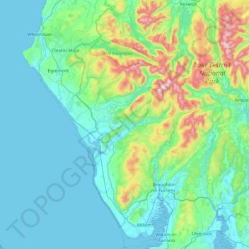
Name: Copeland topographic map, elevation, terrain.
Average elevation: 156 m
Minimum elevation: 0 m
Maximum elevation: 962 m
Other topographic maps
Click on a map to view its topography, its elevation and its terrain.
Egremont
Royaume-Uni > Angleterre > Cumbria > Copeland
Egremont, Copeland, Cumbria, Angleterre, Royaume-Uni
Average elevation: 91 m
Whitehaven
Royaume-Uni > Angleterre > Cumbria > Copeland
Whitehaven, Copeland, Cumbria, Angleterre, Royaume-Uni
Average elevation: 59 m
St. Bees Lighthouse
Royaume-Uni > Angleterre > Cumbria > Copeland > Rottington
St. Bees Lighthouse, Coast to Coast Trail, St. Bees, Rottington, Copeland, Cumbria, Angleterre du Nord-Ouest, Angleterre, CA27 0EU, Royaume-Uni
Average elevation: 36 m