
Make a donation
Gear up for your next adventure:
As an Amazon Associate, this site earns from qualifying purchases at no extra cost to you.
Concrete topographic map
Click on the map to display elevation.
Make a donation
Gear up for your next adventure:
As an Amazon Associate, this site earns from qualifying purchases at no extra cost to you.
Concrete
Mears Field (3W5), formerly known as Concrete Municipal Airport, is located one mile south of Concrete at an elevation of 267 ft MSL.
Make a donation
Gear up for your next adventure:
As an Amazon Associate, this site earns from qualifying purchases at no extra cost to you.
About this map
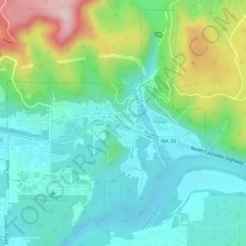
Name: Concrete topographic map, elevation, terrain.
Location: Concrete, Skagit County, Washington, United States (48.52555 -121.76620 48.55064 -121.73391)
Average elevation: 125 m
Minimum elevation: 42 m
Maximum elevation: 341 m
Make a donation
Gear up for your next adventure:
As an Amazon Associate, this site earns from qualifying purchases at no extra cost to you.