Geolocate

Rodewitz topographic map

Click on the map to display elevation.

About this map

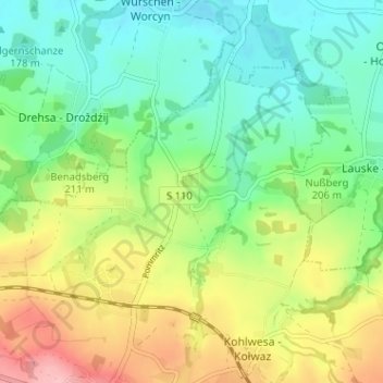
Name: Rodewitz topographic map, elevation, terrain.

Location: Rodewitz, Hochkirch, Bautzen, Sachsen, Deutschland (51.15086 14.56602 51.19086 14.60602)

Average elevation: 205 m

Minimum elevation: 155 m

Maximum elevation: 290 m

Other topographic maps

Click on a map to view its topography, its elevation and its terrain.

02627

Deutschland > Sachsen > Bautzen > Hochkirch > Rodewitz

Average elevation: 188 m

Sornßig

Deutschland > Sachsen > Bautzen > Hochkirch

Average elevation: 347 m

Gear up for your next adventure:

🧴Insect Repellent - Protect yourself from bugs during outdoor adventures
🗺️Topographic Maps - Detailed maps to explore trails, mountains, and wilderness areas
🥾Lightweight Hiking Shoes - Comfortable shoes for day hikes
🕶️Polarized Sunglasses - Reduces glare from snow and water at high elevations
🔨Vehicle Emergency Tool - Safety tool for remote road trips to trailheads

As an Amazon Associate, this site earns from qualifying purchases at no extra cost to you.