Geolocate

Washim topographic map

Click on the map to display elevation.

About this map

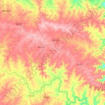
Name: Washim topographic map, elevation, terrain.

Location: Washim, Maharashtra, India (19.88967 77.00141 20.27605 77.37119)

Average elevation: 516 m

Minimum elevation: 430 m

Maximum elevation: 571 m

Gear up for your next adventure:

🧭GPS Handheld Device - Reliable GPS navigation for outdoor adventures
🦶Hiking Shoe Insoles - Added support for high arches and long days on feet
🦌Outdoor Trail Camera - Monitor wildlife activity near your favorite spots
💡Portable Camping Lamp - Rechargeable lamp for campsite lighting
🛶Kayak Accessories - Essential gear for safe and fun kayaking adventures

As an Amazon Associate, this site earns from qualifying purchases at no extra cost to you.