Geolocate

Navasomera topographic map

Click on the map to display elevation.

About this map

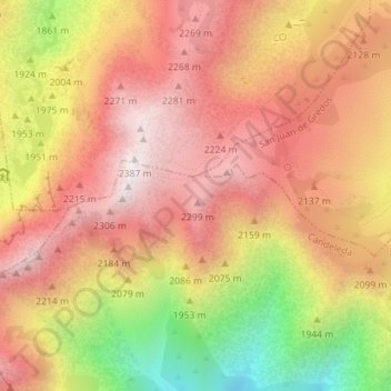
Name: Navasomera topographic map, elevation, terrain.

Location: Navasomera, Candeleda, Ávila, Castilla y León, España (40.23918 -5.27242 40.25918 -5.25242)

Average elevation: 2,033 m

Minimum elevation: 1,470 m

Maximum elevation: 2,381 m

Gear up for your next adventure:

🥾All-Terrain Hiking Boots - Versatile boots for varied hiking conditions
🔦LED Headtorch - Bright and durable light for night activities
🧥Thermal Layer - Insulating layer for cold outdoor conditions
🕶️Polarized Sunglasses - Reduces glare from snow and water at high elevations
🧴First Aid Kit - Essential first aid supplies for outdoor emergencies

As an Amazon Associate, this site earns from qualifying purchases at no extra cost to you.