Geolocate

Rainbow Point topographic map

Click on the map to display elevation.

About this map

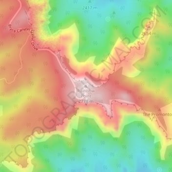
Name: Rainbow Point topographic map, elevation, terrain.

Location: Rainbow Point, Kane County, Utah, United States (37.47504 -112.24046 37.47514 -112.24036)

Average elevation: 2,578 m

Minimum elevation: 2,358 m

Maximum elevation: 2,784 m

Other topographic maps

Click on a map to view its topography, its elevation and its terrain.

Orderville

United States > Utah > Kane County

Average elevation: 1,828 m

Alton

United States > Utah > Kane County

Average elevation: 2,152 m

Big Water

United States > Utah > Kane County

Average elevation: 1,283 m

Orderville

United States > Utah > Kane County

Average elevation: 1,828 m

Kanab

United States > Utah > Kane County

Average elevation: 1,565 m

Kanab

United States > Utah > Kane County

Average elevation: 1,565 m

Kanab

United States > Utah > Kane County

Average elevation: 1,565 m

Orderville

United States > Utah > Kane County

Average elevation: 1,828 m

Gear up for your next adventure:

🪑Ultralight Camping Stool - Compact seating for rest stops during long hikes
🧢Sun Protection Cap - Breathable cap to protect from sun exposure
🥾Lightweight Hiking Boots - Boots for comfort and mobility on long hikes
🔋Emergency Crank Radio - Weather alerts and power without needing batteries
🧦Merino Wool Socks - Moisture-wicking comfort for long-distance hiking

As an Amazon Associate, this site earns from qualifying purchases at no extra cost to you.