
Make a donation
Gear up for your next adventure:
As an Amazon Associate, this site earns from qualifying purchases at no extra cost to you.
Boquete topographic map
Click on the map to display elevation.
Make a donation
Gear up for your next adventure:
As an Amazon Associate, this site earns from qualifying purchases at no extra cost to you.
Boquete
According to archeological information, the nearby area of the Baru Volcano was the place of the first chiefdoms and agricultural societies on what is now the Panama–Costa Rica border, with man-made pottery carbon dated by archaeologists at the Barriles Site Barriles to 300 BC. In Caldera there are also petroglyphs that witness the presence of Isthmo-Colombian villages in this region. During the Spanish Colonization of the Americas, the district of Boquete, along with the rest of the Talamanca highlands, were isolated due to the topographical character of the area, serving as a refuge for the Ngöbe Buglé peoples.
Make a donation
Gear up for your next adventure:
As an Amazon Associate, this site earns from qualifying purchases at no extra cost to you.
About this map
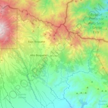
Name: Boquete topographic map, elevation, terrain.
Location: Boquete, Chiriquí, 0413, Panama (8.59495 -82.55959 8.88664 -82.25777)
Average elevation: 1,096 m
Minimum elevation: 188 m
Maximum elevation: 3,313 m
Make a donation
Gear up for your next adventure:
As an Amazon Associate, this site earns from qualifying purchases at no extra cost to you.
Other topographic maps
Click on a map to view its topography, its elevation and its terrain.
Make a donation
Gear up for your next adventure:
As an Amazon Associate, this site earns from qualifying purchases at no extra cost to you.
Make a donation
Gear up for your next adventure:
As an Amazon Associate, this site earns from qualifying purchases at no extra cost to you.
Make a donation
Gear up for your next adventure:
As an Amazon Associate, this site earns from qualifying purchases at no extra cost to you.
Make a donation
Gear up for your next adventure:
As an Amazon Associate, this site earns from qualifying purchases at no extra cost to you.