
Make a donation
Gear up for your next adventure:
As an Amazon Associate, this site earns from qualifying purchases at no extra cost to you.
Savigliano topographic map
Click on the map to display elevation.
Make a donation
Gear up for your next adventure:
As an Amazon Associate, this site earns from qualifying purchases at no extra cost to you.
Savigliano
Savigliano liegt 33 km nördlich von der Provinzhauptstadt Cuneo und knapp 55 km südlich von Turin auf einer Höhe von 320 m s.l.m.. Das Gemeindegebiet umfasst eine Fläche von 110,74 km² und hat 21.780 Einwohner (Stand 31. Dezember 2024). Zur Gemeinde zählen auch die Fraktionen (Frazioni) Apparizione, Canavere, Levaldigi, San Giacomo, San Grato, Sanità, San Salvatore, Santa Rosalia, Solere, Solerette, Suniglia, Tetti Vigna, Cavallotta, Maresco, Tetti Roccia, Rigrasso und Tetti Chiamba.
Make a donation
Gear up for your next adventure:
As an Amazon Associate, this site earns from qualifying purchases at no extra cost to you.
About this map
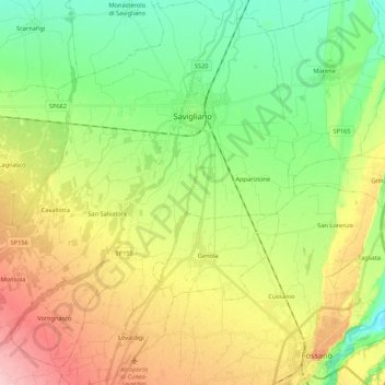
Name: Savigliano topographic map, elevation, terrain.
Location: Savigliano, Cuneo, Piemont, 12038, Italien (44.53655 7.55712 44.68970 7.71456)
Average elevation: 337 m
Minimum elevation: 274 m
Maximum elevation: 431 m
Make a donation
Gear up for your next adventure:
As an Amazon Associate, this site earns from qualifying purchases at no extra cost to you.
Other topographic maps
Click on a map to view its topography, its elevation and its terrain.
Make a donation
Gear up for your next adventure:
As an Amazon Associate, this site earns from qualifying purchases at no extra cost to you.
Make a donation
Gear up for your next adventure:
As an Amazon Associate, this site earns from qualifying purchases at no extra cost to you.
Monviso
Italien > Piemont > Cuneo > Pontechianale
Den Normalweg, der über die Südseite auf den Gipfel führt, erreicht man von Osten (Italien) vom Ausgangsort Crissolo im oberen Po-Tal über die Hütten Pian del Re und Quintino Sella am See Lago Grande di Viso (2640 m). Von Westen (Frankreich) erreicht man den Normalweg über die Hütte Rifugio Vallanta.…
Average elevation: 2,985 m
Make a donation
Gear up for your next adventure:
As an Amazon Associate, this site earns from qualifying purchases at no extra cost to you.
Make a donation
Gear up for your next adventure:
As an Amazon Associate, this site earns from qualifying purchases at no extra cost to you.