
Thank you for supporting this site ❤️
Make a donation
Make a donation
Gear up for your next adventure:
As an Amazon Associate, this site earns from qualifying purchases at no extra cost to you.
Tinfouchy topographic map
Click on the map to display elevation.
Thank you for supporting this site ❤️
Make a donation
Make a donation
Gear up for your next adventure:
As an Amazon Associate, this site earns from qualifying purchases at no extra cost to you.
About this map
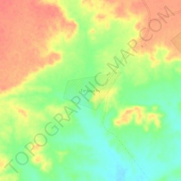
Name: Tinfouchy topographic map, elevation, terrain.
Location: Tinfouchy, Oum el Assel, Daïra Tindouf, Tindouf, Algérie (28.83892 -5.87749 28.87892 -5.83749)
Average elevation: 570 m
Minimum elevation: 541 m
Maximum elevation: 595 m
Thank you for supporting this site ❤️
Make a donation
Make a donation
Gear up for your next adventure:
As an Amazon Associate, this site earns from qualifying purchases at no extra cost to you.