
Make a donation
Gear up for your next adventure:
As an Amazon Associate, this site earns from qualifying purchases at no extra cost to you.
Mutterstadt topographic map
Click on the map to display elevation.
Make a donation
Gear up for your next adventure:
As an Amazon Associate, this site earns from qualifying purchases at no extra cost to you.
Mutterstadt
Die Mutterstadter Flur hat kaum merkbare Höhenunterschiede. Die westlichen Nachbardörfer Dannstadt-Schauernheim und Fußgönheim liegen lediglich fünf bis acht Meter höher. Mutterstadt selbst liegt auf der Niederterrasse, die im Osten jenseits der Gemarkungsgrenze drei bis fünf Meter zur Rheinniederung abfällt. Zu Mutterstadt gehören zusätzlich die Wohnplätze Forsthaus Sternjagen, Hillensheimer Hof, In der Hartkirch, Mandelhof, Maudacher-Eck-Hof, Medartshof, Rheinperle, Schlichthof, Sülzerhof, Wasserwerk und Im Grund.
Make a donation
Gear up for your next adventure:
As an Amazon Associate, this site earns from qualifying purchases at no extra cost to you.
About this map
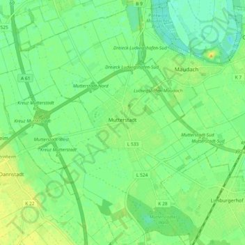
Name: Mutterstadt topographic map, elevation, terrain.
Average elevation: 97 m
Minimum elevation: 87 m
Maximum elevation: 107 m
Make a donation
Gear up for your next adventure:
As an Amazon Associate, this site earns from qualifying purchases at no extra cost to you.