
Purusottampur topographic map
Interactive map
Click on the map to display elevation.
About this map
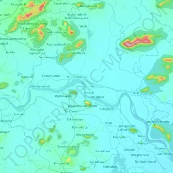
Name: Purusottampur topographic map, elevation, terrain.
Location: Purusottampur, Ganjam, Odisha, Inde (19.40872 84.78819 19.60880 84.98526)
Average elevation: 34 m
Minimum elevation: 3 m
Maximum elevation: 347 m
Other topographic maps
Click on a map to view its topography, its elevation and its terrain.
Bhadrak
Inde > Odisha > Bhadrak Rural
Bhadrak, Bhadrak Rural, Bhadrak District, Odisha, 756100, Inde
Average elevation: 15 m
Sundargarh
Inde > Odisha > Sundargarh Town > Sundargarh
Sundargarh, Sundargarh Town, Sundargarh, Odisha, 770001, Inde
Average elevation: 243 m
Bhubaneswar Municipal Corporation
Inde > Odisha > Bhubaneswar (M.Corp.)
Bhubaneswar Municipal Corporation, Bhubaneswar (M.Corp.), Khordha, Odisha, Inde
Average elevation: 37 m