Geolocate

Dilao topographic map

Click on the map to display elevation.

About this map

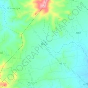
Name: Dilao topographic map, elevation, terrain.

Location: Dilao, Balayan, Batangas, Calabarzon, 4214, Philippines (13.95533 120.66158 13.99533 120.70158)

Average elevation: 68 m

Minimum elevation: 22 m

Maximum elevation: 200 m

Other topographic maps

Click on a map to view its topography, its elevation and its terrain.

Gear up for your next adventure:

🏃Hydration Running Vest - Carry water and maps close to your body for speed
🧳Compression Sacks - Maximize space in your backpack by shrinking gear
🧭GPS Tracker - Track your location in remote areas safely
🧥Packable Rain Jacket - Breathable waterproof layer for unpredictable weather
📷Outdoor Action Camera - Capture high-elevation views and rugged adventures

As an Amazon Associate, this site earns from qualifying purchases at no extra cost to you.