Geolocate

Juniper Ridge topographic map

Click on the map to display elevation.

About this map

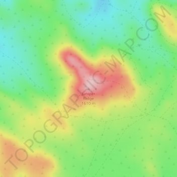
Name: Juniper Ridge topographic map, elevation, terrain.

Location: Juniper Ridge, Harney County, Oregon, United States (43.50150 -119.75095 43.50160 -119.75085)

Average elevation: 1,493 m

Minimum elevation: 1,411 m

Maximum elevation: 1,610 m

Other topographic maps

Click on a map to view its topography, its elevation and its terrain.

Burns

United States > Oregon > Harney County

Average elevation: 1,271 m

Malheur Lake

United States > Oregon > Harney County

Average elevation: 1,249 m

Gear up for your next adventure:

💧Reusable Water Bottle - Durable water bottles for hydration on trails
🔋Lithium AA Batteries - Long-lasting power that performs in extreme cold
🧥Waterproof Pants - Keep dry during rainy hiking conditions
🥾Trail Hiking Socks - Comfortable socks to prevent blisters and fatigue
🔭Compact Binoculars - Lightweight optics for scouting trails and wildlife

As an Amazon Associate, this site earns from qualifying purchases at no extra cost to you.