
Make a donation
Gear up for your next adventure:
As an Amazon Associate, this site earns from qualifying purchases at no extra cost to you.
Rumbak topographic map
Click on the map to display elevation.
Make a donation
Gear up for your next adventure:
As an Amazon Associate, this site earns from qualifying purchases at no extra cost to you.
About this map
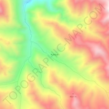
Name: Rumbak topographic map, elevation, terrain.
Location: Rumbak, Leh district, Ladakh, Inde (34.03452 77.41160 34.07452 77.45160)
Average elevation: 4,202 m
Minimum elevation: 3,651 m
Maximum elevation: 4,682 m
Make a donation
Gear up for your next adventure:
As an Amazon Associate, this site earns from qualifying purchases at no extra cost to you.
Other topographic maps
Click on a map to view its topography, its elevation and its terrain.
Nubra
La rivière Shyok rencontre la rivière Noubra (ou rivière Siachan) pour former une grande vallée qui sépare les chaînes du Ladakh et du Karakoram. La rivière Shyok est un affluent de la rivière Indus. L'altitude moyenne de la vallée est de plus de 3 000 m. Le moyen commun d'accéder à cette vallée…
Average elevation: 4,978 m
Kargil district old
À une altitude moyenne de 2 676 mètres, la ville se situe au bord des rives du Suru.
Average elevation: 4,214 m
Make a donation
Gear up for your next adventure:
As an Amazon Associate, this site earns from qualifying purchases at no extra cost to you.
Make a donation
Gear up for your next adventure:
As an Amazon Associate, this site earns from qualifying purchases at no extra cost to you.