
Key Largo topographic map
Click on the map to display elevation.
About this map
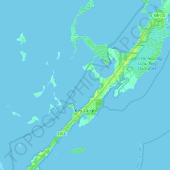
Name: Key Largo topographic map, elevation, terrain.
Location: Key Largo, Monroe County, Florida, United States (25.03376 -80.50134 25.18482 -80.34985)
Average elevation: 1 m
Minimum elevation: -1 m
Maximum elevation: 14 m
Other topographic maps
Click on a map to view its topography, its elevation and its terrain.
Rock Harbor
United States > Florida > Monroe County > Key Largo
Rock Harbor is located at 25°04′37″N 80°27′36″W / 25.077°N 80.46°W / 25.077; -80.46 at an elevation of 10 feet (3 m), relatively high for the Keys.
Average elevation: 1 m