
Make a donation
Gear up for your next adventure:
As an Amazon Associate, this site earns from qualifying purchases at no extra cost to you.
East Greenbush CDP topographic map
Click on the map to display elevation.
Make a donation
Gear up for your next adventure:
As an Amazon Associate, this site earns from qualifying purchases at no extra cost to you.
East Greenbush CDP
The western section of the town along the Hudson River is marked by bluffs that rise to an elevation of between 100 and 300 feet. The little flat land that exists along the river is on the Papscanee Island. Papscanee Island is actually a peninsula, separated from the rest of the town by the Papscanee Creek. The town then spreads out as rolling hills rising towards the east. Mill Creek (formerly Tierken Kill) and Morden Creek are the principal streams of the town.
Make a donation
Gear up for your next adventure:
As an Amazon Associate, this site earns from qualifying purchases at no extra cost to you.
About this map
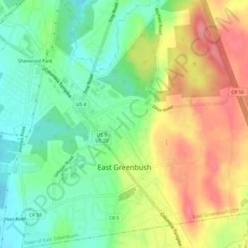
Name: East Greenbush CDP topographic map, elevation, terrain.
Average elevation: 96 m
Minimum elevation: 49 m
Maximum elevation: 171 m
Make a donation
Gear up for your next adventure:
As an Amazon Associate, this site earns from qualifying purchases at no extra cost to you.