Geolocate

Cachipay topographic map

Click on the map to display elevation.

About this map

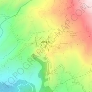
Name: Cachipay topographic map, elevation, terrain.

Location: Cachipay, Colombia (4.72596 -74.44470 4.73360 -74.43243)

Average elevation: 1,567 m

Minimum elevation: 1,303 m

Maximum elevation: 1,854 m

Gear up for your next adventure:

🪑Insulated Seat Pad - Protect your seat from cold rocks and wet logs
🗺️Topographic Maps - Detailed maps to explore trails, mountains, and wilderness areas
🥤Collapsible Travel Cup - Saves space and weight in your mess kit
🥾Lightweight Hiking Shoes - Comfortable shoes for day hikes
🥾Hiking Shoes - Durable and comfortable shoes for trail hiking

As an Amazon Associate, this site earns from qualifying purchases at no extra cost to you.