Geolocate

Alcoreda topographic map

Click on the map to display elevation.

About this map

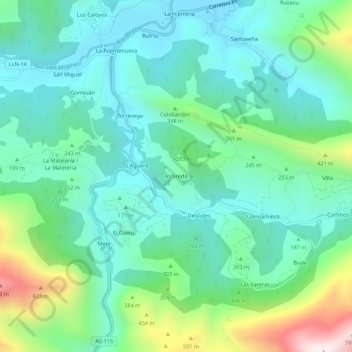
Name: Alcoreda topographic map, elevation, terrain.

Location: Alcoreda, Llanes, Asturias, España (43.36279 -4.92233 43.40279 -4.88233)

Average elevation: 223 m

Minimum elevation: 31 m

Maximum elevation: 809 m

Other topographic maps

Click on a map to view its topography, its elevation and its terrain.

Meré

España > Asturias > Llanes

Average elevation: 351 m

Río de Nueva

España > Asturias > Llanes > Picones

Average elevation: 25 m

Gear up for your next adventure:

🧥Thermal Fleece Jacket - Versatile insulation for changing mountain temperatures
🔋Lithium AA Batteries - Long-lasting power that performs in extreme cold
🥾Waterproof Trail Shoes - Shoes designed to handle wet terrain
🦯Trekking Poles - Reduced impact on joints for steep topographic climbs
🥾Mountain Hiking Boots - High-traction boots for rocky terrain

As an Amazon Associate, this site earns from qualifying purchases at no extra cost to you.