
Make a donation
Gear up for your next adventure:
As an Amazon Associate, this site earns from qualifying purchases at no extra cost to you.
Fox Creek topographic map
Click on the map to display elevation.
Make a donation
Gear up for your next adventure:
As an Amazon Associate, this site earns from qualifying purchases at no extra cost to you.
Fox Creek
Fox Creek is a town in northwest Alberta, Canada. It is located on Highway 43, approximately 259 km (161 mi) northwest of Edmonton and 199 km (124 mi) southeast of Grande Prairie, and has an elevation of 808 m (2,651 ft).
Make a donation
Gear up for your next adventure:
As an Amazon Associate, this site earns from qualifying purchases at no extra cost to you.
About this map
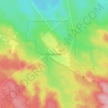
Name: Fox Creek topographic map, elevation, terrain.
Location: Fox Creek, Town of Fox Creek, Alberta, T0H 1P0, Canada (54.35721 -116.84338 54.43721 -116.76338)
Average elevation: 834 m
Minimum elevation: 776 m
Maximum elevation: 913 m
Town of Fox Creek trails, hiking, mountain biking, running and outdoor activities
Make a donation
Gear up for your next adventure:
As an Amazon Associate, this site earns from qualifying purchases at no extra cost to you.