
Make a donation
Gear up for your next adventure:
As an Amazon Associate, this site earns from qualifying purchases at no extra cost to you.
San Pablo Jocopilas topographic map
Click on the map to display elevation.
Make a donation
Gear up for your next adventure:
As an Amazon Associate, this site earns from qualifying purchases at no extra cost to you.
About this map
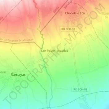
Name: San Pablo Jocopilas topographic map, elevation, terrain.
Location: San Pablo Jocopilas, Suchitepéquez, Guatemala (14.56103 -91.46629 14.62526 -91.39803)
Average elevation: 678 m
Minimum elevation: 456 m
Maximum elevation: 969 m
Make a donation
Gear up for your next adventure:
As an Amazon Associate, this site earns from qualifying purchases at no extra cost to you.
Other topographic maps
Click on a map to view its topography, its elevation and its terrain.
San Antonio Suchitepéquez
Guatemala > Suchitepéquez > San Antonio Suchitepéquez
Average elevation: 403 m
Make a donation
Gear up for your next adventure:
As an Amazon Associate, this site earns from qualifying purchases at no extra cost to you.