Geolocate

Jasper topographic map

Click on the map to display elevation.

About this map

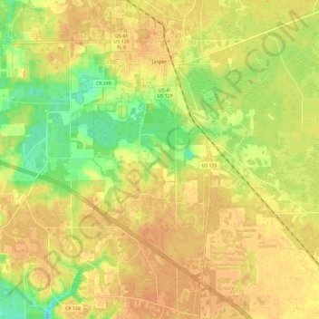
Name: Jasper topographic map, elevation, terrain.

Location: Jasper, Hamilton County, Florida, United States (30.43718 -82.98064 30.53737 -82.92962)

Average elevation: 41 m

Minimum elevation: 20 m

Maximum elevation: 51 m

Other topographic maps

Click on a map to view its topography, its elevation and its terrain.

West Lake

United States > Florida > Hamilton County

Average elevation: 33 m

Rawls

United States > Florida > Hamilton County

Average elevation: 41 m

Gear up for your next adventure:

🥾Waterproof Hiking Boots - Essential footwear for rugged terrain and wet Canadian trails
🧭GPS Outdoor Watch - Smart watch for navigation and fitness tracking in nature
🥤Collapsible Travel Cup - Saves space and weight in your mess kit
🔦LED Flashlight - Powerful and long-lasting flashlight for camping and emergencies
🧊Portable Cooler - Keep food and drinks cold during outdoor adventures

As an Amazon Associate, this site earns from qualifying purchases at no extra cost to you.