Geolocate

Trenton topographic map

Click on the map to display elevation.

About this map

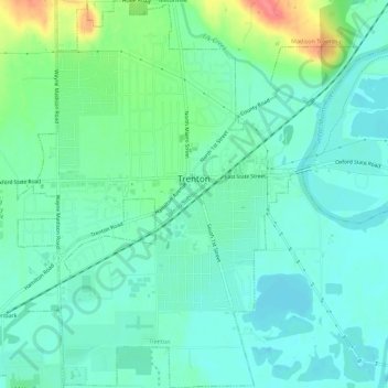
Name: Trenton topographic map, elevation, terrain.

Location: Trenton, Butler County, Ohio, 45067, United States (39.45751 -84.48334 39.50086 -84.43380)

Average elevation: 200 m

Minimum elevation: 183 m

Maximum elevation: 251 m

Other topographic maps

Click on a map to view its topography, its elevation and its terrain.

Williamsdale

United States > Ohio > Butler County

Average elevation: 193 m

Woodsdale

United States > Ohio > Butler County

Average elevation: 204 m

Okeana

United States > Ohio > Butler County

Average elevation: 226 m

West Chester

United States > Ohio > Butler County > West Chester

Average elevation: 231 m

Crawford Woods

United States > Ohio > Butler County > Hamilton

Average elevation: 205 m

Bethany

United States > Ohio > Butler County

Average elevation: 259 m

Darrtown

United States > Ohio > Butler County

Average elevation: 238 m

Wieche Field

United States > Ohio > Butler County > Seven Mile

Average elevation: 208 m

Mayfield

United States > Ohio > Butler County > Middletown

Average elevation: 212 m

Astoria

United States > Ohio > Butler County

Average elevation: 263 m

Macedonia

United States > Ohio > Butler County

Average elevation: 247 m

Peffer Park

United States > Ohio > Butler County > Oxford

Average elevation: 265 m

Gear up for your next adventure:

🎒Hiking Backpack - Lightweight and ergonomic backpacks for day hikes or multi-day treks
💧Collapsible Water Bottle - Space-saving water bottle for outdoor activities
🔪Outdoor Multitool - Versatile tool for repairs and food prep in the wild
🐕Hiking Dog Pack - Let your canine companion carry their own water and food
🧢Beanie Hat - Keep your head warm in cold weather

As an Amazon Associate, this site earns from qualifying purchases at no extra cost to you.