
Thank you for supporting this site ❤️
Make a donation
Make a donation
Gear up for your next adventure:
As an Amazon Associate, this site earns from qualifying purchases at no extra cost to you.
Sedouros topographic map
Click on the map to display elevation.
Thank you for supporting this site ❤️
Make a donation
Make a donation
Gear up for your next adventure:
As an Amazon Associate, this site earns from qualifying purchases at no extra cost to you.
About this map
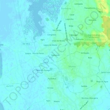
Name: Sedouros topographic map, elevation, terrain.
Location: Sedouros, Bunheiro, Murtosa, Aveiro, 3870-046, Portugal (40.73713 -8.67031 40.77713 -8.63031)
Average elevation: 4 m
Minimum elevation: -3 m
Maximum elevation: 21 m
Thank you for supporting this site ❤️
Make a donation
Make a donation
Gear up for your next adventure:
As an Amazon Associate, this site earns from qualifying purchases at no extra cost to you.