Geolocate

Loma topographic map

Click on the map to display elevation.

About this map

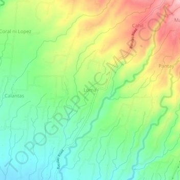
Name: Loma topographic map, elevation, terrain.

Location: Loma, Calaca, Batangas, Calabarzon, 4212, Philippines (13.95212 120.77496 13.99212 120.81496)

Average elevation: 110 m

Minimum elevation: 35 m

Maximum elevation: 224 m

Gear up for your next adventure:

🏕️Camping Hammock - Integrated protection for sleeping between trees
🚲Heavy Duty Bike Lock - Secure your bike at the trailhead or during stops
🧢Sun Protection Cap - Breathable cap to protect from sun exposure
🚲Bike Repair Kit - Essential tools for on-trail mechanical issues
🧢Hiking Hat - Sun-protective and breathable hats for long treks

As an Amazon Associate, this site earns from qualifying purchases at no extra cost to you.