Geolocate

Ourbe topographic map

Click on the map to display elevation.

About this map

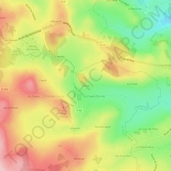
Name: Ourbe topographic map, elevation, terrain.

Location: Ourbe, Champclause, Le Puy-en-Velay, Haute-Loire, Auvergne-Rhône-Alpes, France métropolitaine, France (45.00507 4.16728 45.04507 4.20728)

Average elevation: 1,181 m

Minimum elevation: 1,069 m

Maximum elevation: 1,288 m

Other topographic maps

Click on a map to view its topography, its elevation and its terrain.

Gear up for your next adventure:

🔋Emergency Crank Radio - Weather alerts and power without needing batteries
🧢Hiking Hat - Sun-protective and breathable hats for long treks
🥾Hiking Boots - Sturdy boots providing ankle support and traction on rugged trails
🧥Thermal Layer - Insulating layer for cold outdoor conditions
🥾Waterproof Hiking Shoes - Durable shoes for wet and rugged trails

As an Amazon Associate, this site earns from qualifying purchases at no extra cost to you.