
Thank you for supporting this site ❤️
Make a donation
Make a donation
Gear up for your next adventure:
As an Amazon Associate, this site earns from qualifying purchases at no extra cost to you.
Bure topographic map
Click on the map to display elevation.
Thank you for supporting this site ❤️
Make a donation
Make a donation
Gear up for your next adventure:
As an Amazon Associate, this site earns from qualifying purchases at no extra cost to you.
About this map
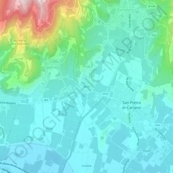
Name: Bure topographic map, elevation, terrain.
Location: Bure, San Pietro in Cariano, Verona, Veneto, 37029, Italië (45.50515 10.85152 45.54515 10.89152)
Average elevation: 197 m
Minimum elevation: 109 m
Maximum elevation: 553 m
Thank you for supporting this site ❤️
Make a donation
Make a donation
Gear up for your next adventure:
As an Amazon Associate, this site earns from qualifying purchases at no extra cost to you.