Geolocate

Muir Beach topographic map

Click on the map to display elevation.

About this map

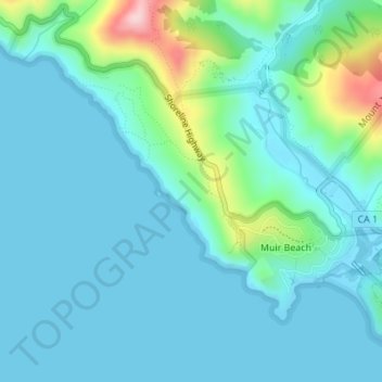
Name: Muir Beach topographic map, elevation, terrain.

Location: Muir Beach, Marin County, California, United States (37.85694 -122.59863 37.87529 -122.57432)

Average elevation: 40 m

Minimum elevation: -2 m

Maximum elevation: 240 m

Gear up for your next adventure:

💡LED Headlamp - Hands-free illumination for night hiking and camping
🥾Approach Shoes - Shoes designed for climbing approaches and rugged trails
👖Convertible Hiking Pants - Zip-off legs to adapt to changing weather conditions
🥾Trail Running Boots - Durable shoes designed for trail running
🌡️Emergency Mylar Blankets - Compact thermal protection for unexpected nights outdoors

As an Amazon Associate, this site earns from qualifying purchases at no extra cost to you.