Geolocate

86438 topographic map

Click on the map to display elevation.

About this map

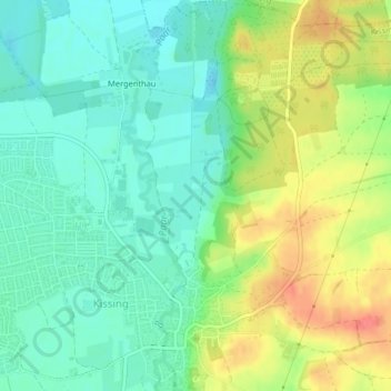
Name: 86438 topographic map, elevation, terrain.

Location: 86438, Kissing, Landkreis Aichach-Friedberg, Bavaria, Germany (48.30642 10.98950 48.30652 10.98960)

Average elevation: 513 m

Minimum elevation: 489 m

Maximum elevation: 552 m

Gear up for your next adventure:

🎒Fully Waterproof Backpack - Total protection for photography gear and electronics
🧴Sunscreen SPF - Broad-spectrum sunscreen for outdoor activities
Camping Coffee Maker - Brew fresh coffee anywhere on the topographic map
🩹Moleskin Blister Pads - Direct protection for painful foot pressure points
🧥Ultralight Puffy Jacket - Maximum warmth that packs down to the size of an orange

As an Amazon Associate, this site earns from qualifying purchases at no extra cost to you.