Geolocate

Mogi Mirim topographic map

Click on the map to display elevation.

Mogi Mirim

Mogi Mirim is a municipality located in the eastern part of São Paulo State, in Brazil. The population is 93,650 (2020 est.) in an area of 498 km². The elevation is 611 m.

Wikipedia (CC-BY-SA 3.0)

About this map

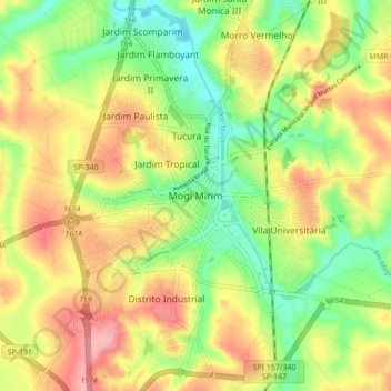
Name: Mogi Mirim topographic map, elevation, terrain.

Location: Mogi Mirim, Região Imediata de Mogi Guaçu, Região Geográfica Intermediária de Campinas, São Paulo, Southeast Region, 13800-200, Brazil (-22.47312 -46.99825 -22.39312 -46.91825)

Average elevation: 655 m

Minimum elevation: 598 m

Maximum elevation: 717 m

Gear up for your next adventure:

🧦Crew Hiking Socks - Comfortable socks for long-distance hikes
🚲Heavy Duty Bike Lock - Secure your bike at the trailhead or during stops
🧰Emergency Multi-Tool - Compact multi-tool for outdoor survival
Camping Essentials - All-in-one gear for a comfortable camping trip
🚲Bike Repair Kit - Essential tools for on-trail mechanical issues

As an Amazon Associate, this site earns from qualifying purchases at no extra cost to you.