
Make a donation
Gear up for your next adventure:
As an Amazon Associate, this site earns from qualifying purchases at no extra cost to you.
Casalta III topographic map
Click on the map to display elevation.
Make a donation
Gear up for your next adventure:
As an Amazon Associate, this site earns from qualifying purchases at no extra cost to you.
About this map
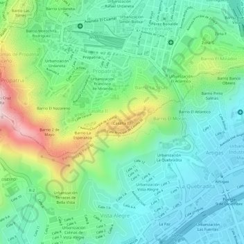
Name: Casalta III topographic map, elevation, terrain.
Average elevation: 1,006 m
Minimum elevation: 890 m
Maximum elevation: 1,259 m
Make a donation
Gear up for your next adventure:
As an Amazon Associate, this site earns from qualifying purchases at no extra cost to you.
Other topographic maps
Click on a map to view its topography, its elevation and its terrain.
Conejo Blanco
Venezuela > Distrito Capital > Municipio Libertador > Caracas
Average elevation: 1,306 m
Make a donation
Gear up for your next adventure:
As an Amazon Associate, this site earns from qualifying purchases at no extra cost to you.
Jardines Quinta de Anauco
Venezuela > Distrito Capital > Municipio Libertador > Caracas
Average elevation: 970 m
Plaza La Concordia
Venezuela > Distrito Capital > Municipio Libertador > Caracas
Average elevation: 916 m
Bajada de Tazón
Venezuela > Distrito Capital > Municipio Libertador > Caracas
Average elevation: 1,010 m
Plaza Caracas
Venezuela > Distrito Capital > Municipio Libertador > Caracas
Average elevation: 1,027 m
Make a donation
Gear up for your next adventure:
As an Amazon Associate, this site earns from qualifying purchases at no extra cost to you.
Plaza Madariaga
Venezuela > Distrito Capital > Municipio Libertador > Caracas
Average elevation: 924 m
Plaza Capuchinos
Venezuela > Distrito Capital > Municipio Libertador > Caracas
Average elevation: 925 m
Plaza Madariaga
Venezuela > Distrito Capital > Municipio Libertador > Caracas
Average elevation: 924 m
Make a donation
Gear up for your next adventure:
As an Amazon Associate, this site earns from qualifying purchases at no extra cost to you.
Castillo Blanco
Venezuela > Distrito Capital > Municipio Libertador > Caracas > Las Canoas
Average elevation: 1,245 m