
Darcheti topographic map
Click on the map to display elevation.
About this map
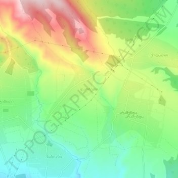
Name: Darcheti topographic map, elevation, terrain.
Location: Darcheti, Gurjaani Municipality, Kakheti, Georgia (41.66103 45.69534 41.70103 45.73534)
Average elevation: 781 m
Minimum elevation: 654 m
Maximum elevation: 964 m
Other topographic maps
Click on a map to view its topography, its elevation and its terrain.
Gurjaani
Georgia > Kakheti > Gurjaani Municipality
Gurjaani (Georgian: გურჯაანი) is a town in Kakheti, a region in eastern Georgia, and the seat of the Gurjaani Municipality. It is located in the Alazani River Plain, at an elevation of 415 m above sea level.
Average elevation: 426 m