
Mediona topographic map
Click on the map to display elevation.
About this map
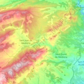
Name: Mediona topographic map, elevation, terrain.
Location: Mediona, Alt Penedès, Barcelona, Catalonia, 08773, Spain (41.44375 1.57032 41.51328 1.70238)
Average elevation: 470 m
Minimum elevation: 221 m
Maximum elevation: 786 m
Other topographic maps
Click on a map to view its topography, its elevation and its terrain.
les Casetes del Pujol
Spain > Catalonia > Alt Penedès > Castellví de la Marca > la Múnia
Average elevation: 185 m