Geolocate

Ridgecrest topographic map

Click on the map to display elevation.

Ridgecrest

Walker Pass (elevation 5,250 ft (1.60 km)) is a mountain pass by Lake Isabella in the southern Sierra Nevada mountains. It is located in northeastern Kern County, approximately 53 mi (85 km) ENE of Bakersfield and 10 mi (16 km) WSW of Ridgecrest. The pass provides a route between the San Joaquin Valley on the west and the Mojave Desert on the east.[citation needed]

About this map

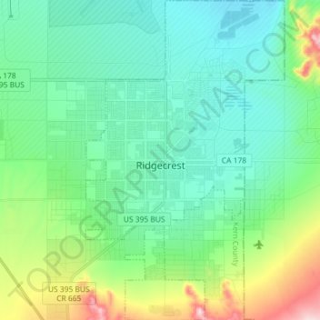
Name: Ridgecrest topographic map, elevation, terrain.

Location: Ridgecrest, Kern County, California, 93555, United States (35.56389 -117.70589 35.68079 -117.61640)

Average elevation: 740 m

Minimum elevation: 667 m

Maximum elevation: 1,022 m

Other topographic maps

Click on a map to view its topography, its elevation and its terrain.

Quality

United States > California > Kern County

Average elevation: 155 m

Fruitvale

United States > California > Kern County

Average elevation: 122 m

Rosedale

United States > California > Kern County

Average elevation: 113 m

Baker

United States > California > Kern County > Boron

Average elevation: 765 m

Rio Bravo

United States > California > Kern County

Average elevation: 97 m

Cameron

United States > California > Kern County

Average elevation: 1,309 m

Gear up for your next adventure:

🥾Approach Shoes - Shoes designed for climbing approaches and rugged trails
🛶Waterproof Dry Bags - Keep electronics and clothes dry during river crossings
🧤Insulated Winter Gloves - Heavy-duty protection for sub-zero Canadian adventures
🔦LED Headlamp - Hands-free lighting for early morning starts or late finishes
🥾Durable Hiking Shoes - Long-lasting shoes for frequent hiking

As an Amazon Associate, this site earns from qualifying purchases at no extra cost to you.