Geolocate

Subachoque topographic map

Click on the map to display elevation.

About this map

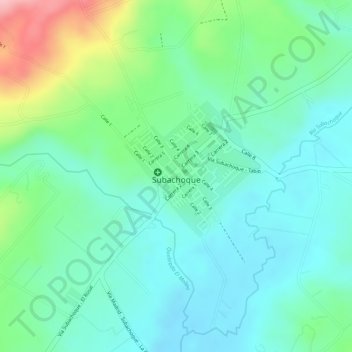
Name: Subachoque topographic map, elevation, terrain.

Location: Subachoque, Cundinamarca, Colombia (4.92288 -74.18147 4.93360 -74.16596)

Average elevation: 2,659 m

Minimum elevation: 2,611 m

Maximum elevation: 2,778 m

Gear up for your next adventure:

🧰Emergency Multi-Tool - Compact multi-tool for outdoor survival
🧤Thermal Hiking Gloves - Grip-enhanced gloves for cold-weather altitude trekking
Tent Footprint - Protect tent floor and increase durability
🥾Light Hiking Boots - Lightweight and comfortable boots for day hikes
🔥Camping Stove - Portable stoves to cook outdoors with ease

As an Amazon Associate, this site earns from qualifying purchases at no extra cost to you.