
Make a donation
Gear up for your next adventure:
As an Amazon Associate, this site earns from qualifying purchases at no extra cost to you.
Mandeville topographic map
Click on the map to display elevation.
Make a donation
Gear up for your next adventure:
As an Amazon Associate, this site earns from qualifying purchases at no extra cost to you.
Mandeville
Mandeville (Jamaican Patois: Mandivl) is the capital and largest town in the parish of Manchester in the county of Middlesex, Jamaica. In 2022, the town had an estimated population of 21,686. It is located on an inland plateau at an altitude of 628 m (2061 feet), and is 103 km (64 mi) west of Kingston. It is the only parish capital of Jamaica not located on the coast or on a major river.
Make a donation
Gear up for your next adventure:
As an Amazon Associate, this site earns from qualifying purchases at no extra cost to you.
About this map
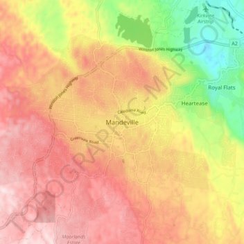
Name: Mandeville topographic map, elevation, terrain.
Location: Mandeville, Manchester, Middlesex County, Jamaica (18.00313 -77.54741 18.08313 -77.46741)
Average elevation: 615 m
Minimum elevation: 358 m
Maximum elevation: 798 m
Make a donation
Gear up for your next adventure:
As an Amazon Associate, this site earns from qualifying purchases at no extra cost to you.
Other topographic maps
Click on a map to view its topography, its elevation and its terrain.