
Thank you for supporting this site ❤️
Make a donation
Make a donation
Gear up for your next adventure:
As an Amazon Associate, this site earns from qualifying purchases at no extra cost to you.
Broich topographic map
Click on the map to display elevation.
Thank you for supporting this site ❤️
Make a donation
Make a donation
Gear up for your next adventure:
As an Amazon Associate, this site earns from qualifying purchases at no extra cost to you.
Broich
Der Ort liegt in einer Höhe von 200 Metern über NN auf den Hängen des Westerwaldes. Nachbarorte sind Hanf im Nordosten, Köschbusch im Osten und Bennerscheid (Stadt Königswinter) im Westen.
Thank you for supporting this site ❤️
Make a donation
Make a donation
Gear up for your next adventure:
As an Amazon Associate, this site earns from qualifying purchases at no extra cost to you.
About this map
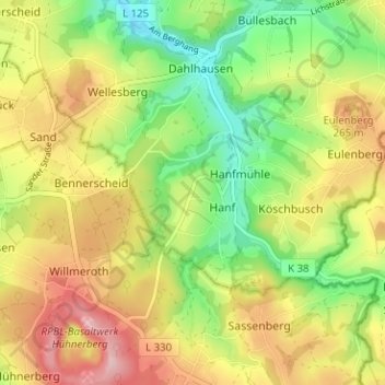
Name: Broich topographic map, elevation, terrain.
Average elevation: 203 m
Minimum elevation: 112 m
Maximum elevation: 305 m
Thank you for supporting this site ❤️
Make a donation
Make a donation
Gear up for your next adventure:
As an Amazon Associate, this site earns from qualifying purchases at no extra cost to you.