Geolocate

Crofton topographic map

Click on the map to display elevation.

About this map

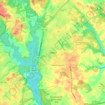
Name: Crofton topographic map, elevation, terrain.

Location: Crofton, Anne Arundel County, Maryland, 21114, United States (38.96178 -76.72747 39.04178 -76.64747)

Average elevation: 35 m

Minimum elevation: 4 m

Maximum elevation: 68 m

Other topographic maps

Click on a map to view its topography, its elevation and its terrain.

Severn

United States > Maryland > Anne Arundel County > Severn

Average elevation: 47 m

Deale

United States > Maryland > Anne Arundel County > Deale

Average elevation: 5 m

Odenton

United States > Maryland > Anne Arundel County > Odenton

Average elevation: 41 m

Gear up for your next adventure:

🥾Durable Hiking Shoes - Long-lasting shoes for frequent hiking
🛶Kayak Accessories - Essential gear for safe and fun kayaking adventures
🧥Insulated Jacket - Keep warm in cold outdoor conditions
🔦LED Headlamp - Hands-free lighting for early morning starts or late finishes
🥾Mountain Trail Shoes - High-traction shoes for mountain trails

As an Amazon Associate, this site earns from qualifying purchases at no extra cost to you.