
Make a donation
Gear up for your next adventure:
As an Amazon Associate, this site earns from qualifying purchases at no extra cost to you.
Oberbüscherhof topographic map
Click on the map to display elevation.
Make a donation
Gear up for your next adventure:
As an Amazon Associate, this site earns from qualifying purchases at no extra cost to you.
Oberbüscherhof
Die Karte Topographia Ducatus Montani aus dem Jahre 1715 zeigt den Hof unter dem Namen ober Buscherhof. Im 18. Jahrhundert gehörte der Ort zum Kirchspiel Leichlingen im bergischen Amt Miselohe. Die Topographische Aufnahme der Rheinlande von 1824 und die Preußische Uraufnahme von 1844 verzeichnet den Hof als Ob.Buscherhof bzw. Ob.Büscherhof.
Make a donation
Gear up for your next adventure:
As an Amazon Associate, this site earns from qualifying purchases at no extra cost to you.
About this map
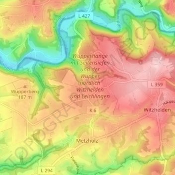
Name: Oberbüscherhof topographic map, elevation, terrain.
Average elevation: 169 m
Minimum elevation: 69 m
Maximum elevation: 249 m
Make a donation
Gear up for your next adventure:
As an Amazon Associate, this site earns from qualifying purchases at no extra cost to you.
Other topographic maps
Click on a map to view its topography, its elevation and its terrain.
42799
Deutschland > Nordrhein-Westfalen > Rheinisch-Bergischer Kreis > Leichlingen > Metzholz > Koltershäuschen
Average elevation: 143 m