Geolocate

Riale topographic map

Click on the map to display elevation.

About this map

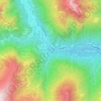
Name: Riale topographic map, elevation, terrain.

Location: Riale, Piode, Vercelli, Piemont, 13023, Italy (45.74852 8.03196 45.78852 8.07196)

Average elevation: 1,172 m

Minimum elevation: 676 m

Maximum elevation: 1,949 m

Gear up for your next adventure:

🧰Survival Kit - Essential gear for emergencies in the wilderness
👟Leg Gaiters - Keep debris, mud, and snow out of your boots
🥾All-Terrain Hiking Boots - Versatile boots for varied hiking conditions
🧴Outdoor Sunscreen - High SPF protection for high-altitude UV exposure
🧭Orienteering Kit - Tools for map reading and navigation in the wild

As an Amazon Associate, this site earns from qualifying purchases at no extra cost to you.