
Silkeborg Kommune topographic map
Interactive map
Click on the map to display elevation.
About this map
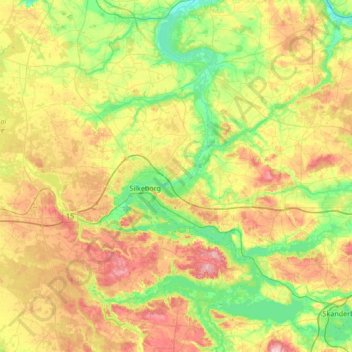
Name: Silkeborg Kommune topographic map, elevation, terrain.
Location: Silkeborg Kommune, Jutland central, Danemark (55.99398 9.22196 56.36956 9.86108)
Average elevation: 67 m
Minimum elevation: 4 m
Maximum elevation: 168 m
Other topographic maps
Click on a map to view its topography, its elevation and its terrain.
Hobbel
Danemark > Jutland central > Neder Randlev
Hobbel, Neder Randlev, Odder Kommune, Jutland central, 8300, Danemark
Average elevation: 14 m
Knebel
Danemark > Jutland central > Knebel
Knebel, Syddjurs Kommune, Jutland central, Danemark
Average elevation: 18 m
Haldrup
Danemark > Jutland central > Haldrup
Haldrup, Horsens Kommune, Jutland central, Danemark
Average elevation: 29 m
Virklund
Danemark > Jutland central > Virklund
Virklund, Silkeborg Kommune, Jutland central, 8653, Danemark
Average elevation: 60 m