Geolocate

Hamilton topographic map

Click on the map to display elevation.

About this map

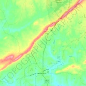
Name: Hamilton topographic map, elevation, terrain.

Location: Hamilton, Harris County, Georgia, 31881, United States (32.74518 -84.89725 32.83080 -84.84119)

Average elevation: 247 m

Minimum elevation: 187 m

Maximum elevation: 358 m

Other topographic maps

Click on a map to view its topography, its elevation and its terrain.

Whitesville

United States > Georgia > Harris County

Average elevation: 207 m

Dowdell Knob

United States > Georgia > Harris County

Average elevation: 322 m

Pine Mountain

United States > Georgia > Harris County

Average elevation: 274 m

Gear up for your next adventure:

🥾Mountain Hiking Shoes - Shoes with superior grip for mountainous terrain
🦌Outdoor Trail Camera - Monitor wildlife activity near your favorite spots
💧Reusable Water Bottle - Durable water bottles for hydration on trails
🧼Travel Hand Sanitizer - Keep hands clean when water is scarce
❄️Traction Ice Cleats - Slip-on spikes for icy trails and winter hiking

As an Amazon Associate, this site earns from qualifying purchases at no extra cost to you.