Geolocate

Oxnard topographic map

Click on the map to display elevation.

About this map

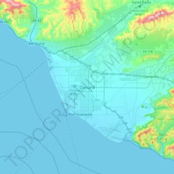
Name: Oxnard topographic map, elevation, terrain.

Location: Oxnard, Ventura County, California, 93031, United States (34.03763 -119.34038 34.35763 -119.02038)

Average elevation: 69 m

Minimum elevation: -1 m

Maximum elevation: 703 m

Gear up for your next adventure:

🎒Fully Waterproof Backpack - Total protection for photography gear and electronics
🦟Insect Repellent - Keep mosquitoes and black flies away in wooded areas
🛌Insulated Sleeping Pad - Critical thermal barrier between you and the cold ground
🧥Softshell Jacket - Windproof and breathable jacket for hiking
🥾Hiking Shoes - Durable and comfortable shoes for trail hiking

As an Amazon Associate, this site earns from qualifying purchases at no extra cost to you.