
Thank you for supporting this site ❤️
Make a donation
Make a donation
Gear up for your next adventure:
As an Amazon Associate, this site earns from qualifying purchases at no extra cost to you.
Lombise topographic map
Click on the map to display elevation.
Thank you for supporting this site ❤️
Make a donation
Make a donation
Gear up for your next adventure:
As an Amazon Associate, this site earns from qualifying purchases at no extra cost to you.
About this map
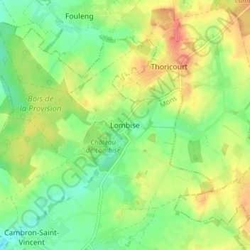
Name: Lombise topographic map, elevation, terrain.
Location: Lombise, Lens, Bergen, Henegouwen, Wallonië, 7870, België (50.58077 3.91979 50.62077 3.95979)
Average elevation: 77 m
Minimum elevation: 53 m
Maximum elevation: 106 m
Thank you for supporting this site ❤️
Make a donation
Make a donation
Gear up for your next adventure:
As an Amazon Associate, this site earns from qualifying purchases at no extra cost to you.