
83064 topographic map
Click on the map to display elevation.
About this map
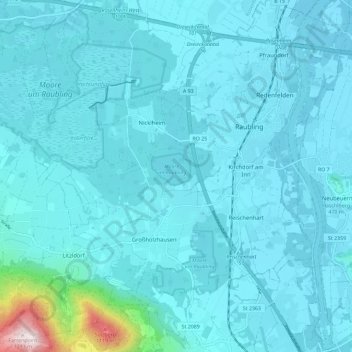
Name: 83064 topographic map, elevation, terrain.
Location: 83064, Raubling, Landkreis Rosenheim, Bayern, Deutschland (47.73946 12.03278 47.81716 12.13307)
Average elevation: 503 m
Minimum elevation: 441 m
Maximum elevation: 1,268 m
Other topographic maps
Click on a map to view its topography, its elevation and its terrain.
Hochrunstfilze
Deutschland > Bayern > Landkreis Rosenheim > Raubling > Nicklheim
Average elevation: 468 m
Kleinholzhausen
Deutschland > Bayern > Landkreis Rosenheim > Raubling > Großholzhausen
Average elevation: 506 m
Obermühl
Deutschland > Bayern > Landkreis Rosenheim > Raubling > Reischenhart > Obermühl
Average elevation: 463 m