
Make a donation
Gear up for your next adventure:
As an Amazon Associate, this site earns from qualifying purchases at no extra cost to you.
Ediger-Eller topographic map
Click on the map to display elevation.
Make a donation
Gear up for your next adventure:
As an Amazon Associate, this site earns from qualifying purchases at no extra cost to you.
Ediger-Eller
Noch ältere Besiedelungsspuren – Überreste des Steinwalls einer Fliehburg aus keltischer Zeit – finden sich auf dem auf der gegenüberliegenden Seite der Mosel befindlichen Berg Hochkessel. Auf der dem Hunsrück zugewandten Seite der Mosel befindet sich ein römisch-gallisches Gräberfeld in der Nähe der Neefer Peters-Kapelle. Die spärlichen Überreste eines Garnisonsaußenpostens einer römischen Legion findet man auf dem Höhenzug des Calmont.
Make a donation
Gear up for your next adventure:
As an Amazon Associate, this site earns from qualifying purchases at no extra cost to you.
About this map
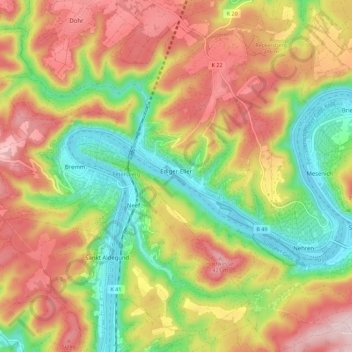
Name: Ediger-Eller topographic map, elevation, terrain.
Average elevation: 256 m
Minimum elevation: 83 m
Maximum elevation: 439 m
Make a donation
Gear up for your next adventure:
As an Amazon Associate, this site earns from qualifying purchases at no extra cost to you.